HTTP/2 301
date: Wed, 28 Jan 2026 10:03:13 GMT
content-length: 0
location: https://geographyrealm.com/
vary: accept-encoding
report-to: {"group":"cf-nel","max_age":604800,"endpoints":[{"url":"https://a.nel.cloudflare.com/report/v4?s=Jl1cdOBQpylgHJTkPdhi6JCznk%2FYvv8q1hWqWLg9Z3vvxE6nkIhrhFDMiIJajG3c7rFD6uC9mrwbnQ3cbLlbFT%2BwFOZuSn2dwvc5RbA%3D"}]}
nel: {"report_to":"cf-nel","success_fraction":0.0,"max_age":604800}
server: cloudflare
cf-ray: 9c4fa8a14ffc3a2d-BOM
alt-svc: h3=":443"; ma=86400
HTTP/2 301
date: Wed, 28 Jan 2026 10:03:14 GMT
content-type: text/html
location: https://www.geographyrealm.com/
x-hosted-by: BigScoots
server: cloudflare
cf-cache-status: DYNAMIC
nel: {"report_to":"cf-nel","success_fraction":0.0,"max_age":604800}
report-to: {"group":"cf-nel","max_age":604800,"endpoints":[{"url":"https://a.nel.cloudflare.com/report/v4?s=xdvoD%2Bnv9L%2FgWSqO%2BJtkIUslY8iTd05xsUvHSDuWzjf5Ne6qKc7ZVkU0CPo7Y2ZknRF3gERBjaWg97zbZnrCDK2LNJF%2FwHoaObZP0y2KnLifYQ%3D%3D"}]}
cf-ray: 9c4fa8a1db7e4bfa-BOM
alt-svc: h3=":443"; ma=86400
HTTP/2 200
date: Wed, 28 Jan 2026 10:03:14 GMT
content-type: text/html; charset=UTF-8
content-encoding: gzip
cf-ray: 9c4fa8a62f355ace-BLR
cf-cache-status: HIT
cache-control: public, s-maxage=31536000, max-age=60, must-revalidate
last-modified: Wed, 28 Jan 2026 01:04:19 GMT
link:
; rel=preload; as=image
strict-transport-security: max-age=15552000; preload
vary: Accept-Encoding
content-security-policy: block-all-mixed-content;
x-bigscoots-cache: cache
x-bigscoots-cache-control: public, s-maxage=31536000, max-age=60, must-revalidate
x-bigscoots-cache-plan: boost
x-content-type-options: nosniff
x-hosted-by: BigScoots
x-ua-compatible: IE=edge
x-xss-protection: 1; mode=block
set-cookie: __cf_bm=phyCrhzPO5RApGCb3TtIUz5CqHqy8hM.qWtcyBmaLKM-1769594594-1.0.1.1-ic4_79oIPyOjHVOzSH0WHs1F_3tIIso9TzOKE1FREr7N_4b0_NANIxSPfMU3kiVlkgTIPpt8TYPS_hn0_Cv_UehfGcH2pANaOyp4xnXn8bE; path=/; expires=Wed, 28-Jan-26 10:33:14 GMT; domain=.www.geographyrealm.com; HttpOnly; Secure; SameSite=None
set-cookie: _cfuvid=tRXEhSN9i6lNJ.uiqvHmUkwSYErnviLxHxiinkqCDjU-1769594594444-0.0.1.1-604800000; path=/; domain=.www.geographyrealm.com; HttpOnly; Secure; SameSite=None
x-bigscoots-cache-status: HIT
server: cloudflare
alt-svc: h3=":443"; ma=86400
Geography and GIS - Geography Realm
Skip to content
A 2023 heatwave killed nearly all of Florida’s main reef-building corals, leaving the reef functionally extinct.
Read More
GIS and Geospatial Technologies
More

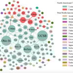
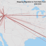
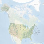
Learn how to create a radial flow map in QGIS to visualize migration using metro-to-metro data from the U.S. Census Bureau.
Maps and cartography
More
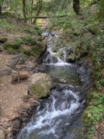
Groundwater stored over many years is a significant contributor to streamflow in Western United States mountains according to a published study.
Bubbles created by the movement of waves can influence how much carbon dioxide is absorbed by the ocean.
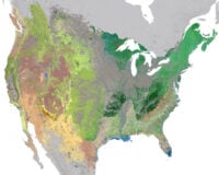
NatureServe has developed an updated 30-meter hexagon map of regional ecosystems in the contiguous United States and adjacent areas.
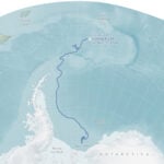
Lake Chapala was formed at the intersection of three grabens.
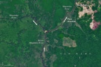
Read about how the Amazon once flowed east to west and how the strength of Hurricane Isaac once change the course of the Mississippi river.
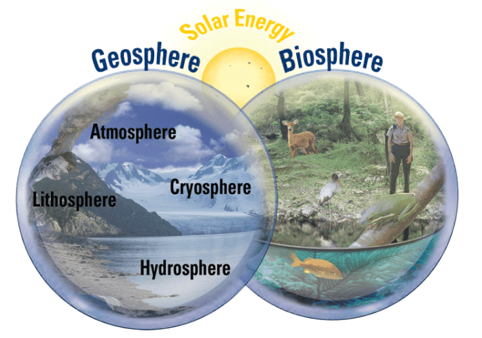
The systems of the earth can be divided into two main areas: geosphere and biosphere.
Measuring the economic benefits of wildlife and outdoor areas supports conservation with tools like the NPS Visitor Spending Effects.